
The City - and surrounding areas
The City was generally regarded as the small square highlighted in the map below, and was a tight network of squalid, terraced housing for the lower class workers, usually working in the mills and factories around the bottom of Pellon Lane and at the Dean Clough mills. But this page also looks at the wider area of similar housing at 'Stannary' and shows the living standards which, along with many other areas at the time, deemed 'unfit for use' in the government report mainly due to size, sanitary and living conditions.

St.James's Road

  |
 |


See Alhambra - OddFellows Hall


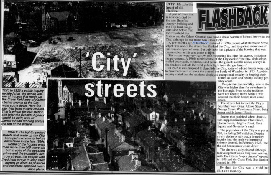
First buses moved into and through Cross Field bus station in the mid-fifties, more than a decade and a half after the opening of the Odeon on the 'City' site


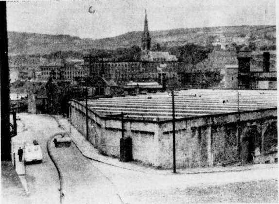
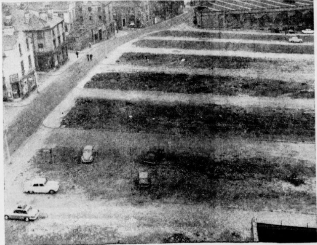
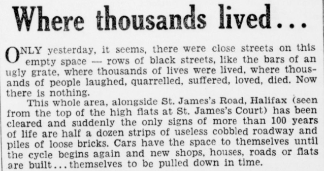
The 4 pictures above show a clear time lapse of the 'Before and After' demolition views of the St. James's Road area.

Looking in the opposite direction


St James's Church, pictured behind the shop in the photo above, was at one time, the third oldest church in Halifax, after the Parish church and the Holy Trinity. For many years, the first two churches could cope with the religious needs of the town, but when the Rev Titus Knight became the vicar of Halifax he set about the task of providing for the growing population of the town and decided the town needed five churches.
Plans for the erection of St. James's were not completed until Archdeacon Musgrave became vicar of Halifax. It was opened for public worship on Jan 2nd 1832. It's architecture is decidedly original, although it should be pointed out that the first plan that the architect submitted was for a building of singular beauty. Funds were lacking, however, and the ecclesiastical authorities had to dcall for less pretentious plans.


St. James's Road with North Parade on the right

 |
 |
Stannary

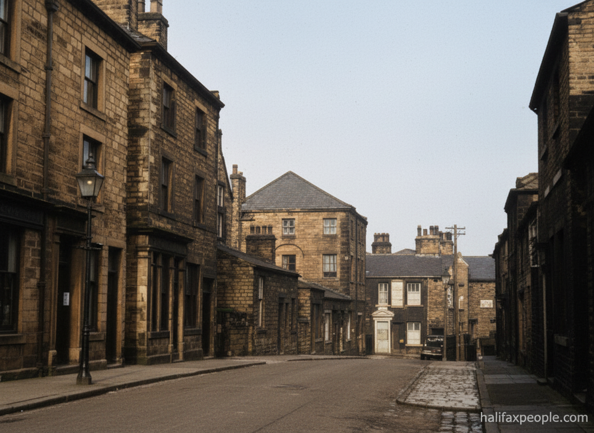
enhanced
 |
 |

Stannary Inn pub at the bottom of Green Lane (now Richmond Road- where the police station is)


Stannary Lane looking down towards Dean Clough (drawing by John.L.Berbiers)

Stannary House
Great Albion Street

 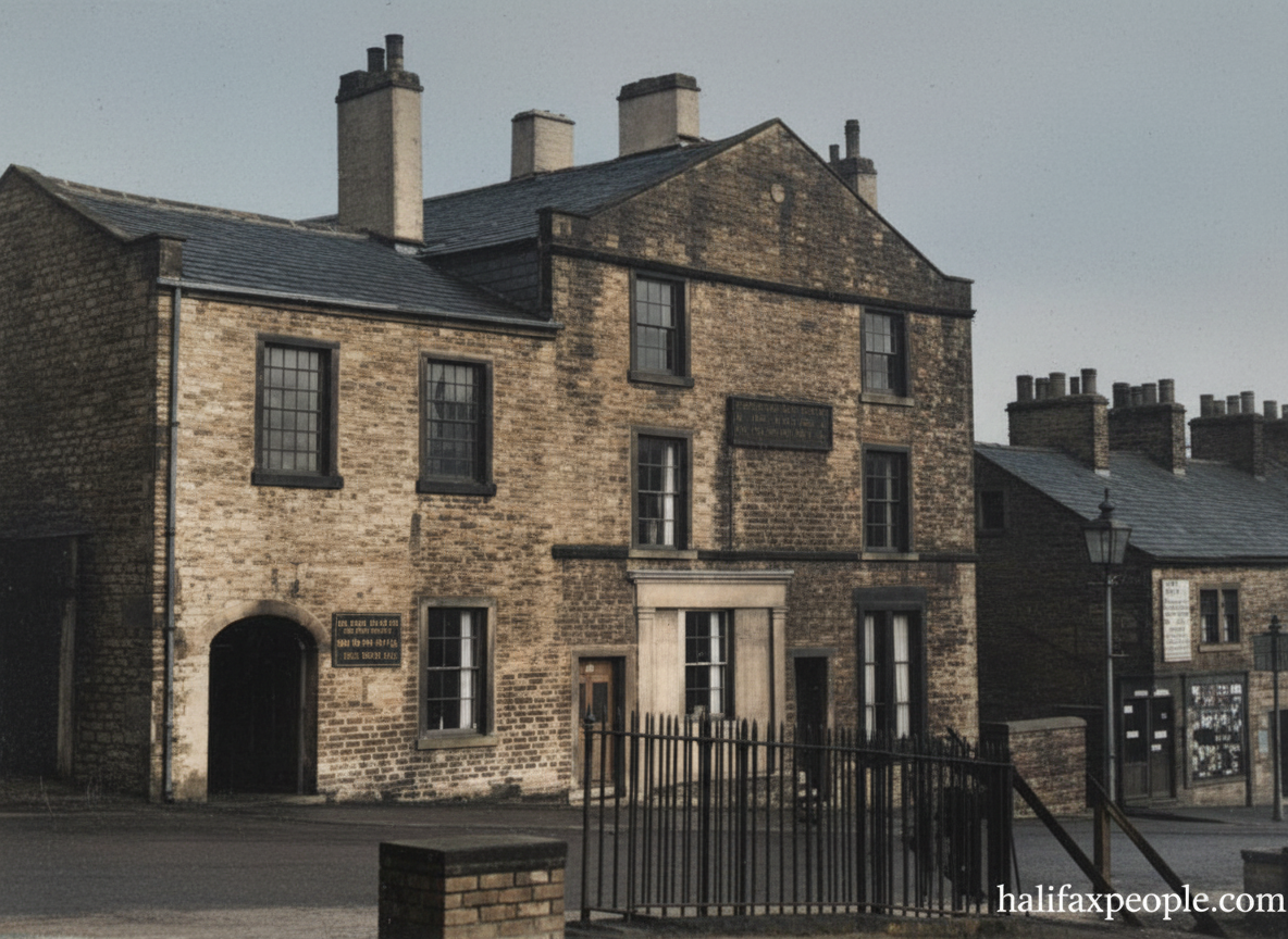 |
 |

Last
Days of the ‘City’ in the Heart of Town
A Halifax flashback, retold
There was once a little “City” inside Halifax — not a grand place of cathedrals and boulevards, but a tight-knit quarter of narrow streets, courts, and back-to-backs packed into the very centre. It sat right where later generations came to know the Top Rank bingo club, the Odeon cinema, the Benefits Office, and Cross Field Bus Station.
This was not a single street you could stride through in a minute.
It was a maze — a lived-in tangle of passages and yards where
families made do with what they had, and where the names of streets
mattered because they were home.
A crowded quarter — and a decision made
By the early 1920s, Halifax Corporation had begun looking hard at conditions in this part of town. Inspectors could admire the efforts of residents to keep their homes as clean as possible, but the reality remained: the housing was old, cramped, and difficult to improve to modern standards.
The decision followed that the area would have to be cleared. It
was not a quick process, and it was not a simple one. People did not
always want to leave, even when the writing was on the wall.
Names that vanished from the map
When the demolitions finally came, whole clusters of names disappeared with them. Among those remembered in the records are:
- Fleet Street
- Pitt Street
- Milk Street
- Swan Street
- Governor’s Street
- Haigh’s Court
- Aked’s Court
- Crossley Court
- Huson’s Square
- Lowes Court
Today, those names are ghosts — but the photographs survive.
A long gap before the “new” arrived
Even after clearance, the site did not immediately become the modern centre people might imagine. The Odeon “super cinema” was not completed until 1938, and then the Second World War intervened. Cross Field Bus Station, planned as part of the new Halifax, did not open until 1954.
By then, memories of the old “City” had begun to fade — but these atmospheric images bring it back sharply: the stone, the cobbles, the tight yards, and the sense of a place that once bustled with ordinary life.
If you’ve got a grandparent who ever said, “We used to call it
the City,” this is what they meant. Not a place on a map today —
but a place that lived, breathed, and then disappeared.
If you recognise any corner, doorway, or street name from these pictures, send it in. Halifax history is best when it’s remembered together.

The main road on the right of the photo is Pellon Lane (bottom of picture travels up towards town). A large area was demolished to make way for the Odeon and what became the bus station but was still a car park in the above photo

Pellon Lane runs from left to right (towards town) in the top half of the picture.

top - North Bridge, centre - Corporation Street(left to right)
 |
 |
Looking up Pellon Lane with the Grand Junction Hotel on the left and Ebenezer Primitive Methodist Church on the right
 |
 |
 |
 |

This bottom half of this photo captures nearly all of 'The City' area.
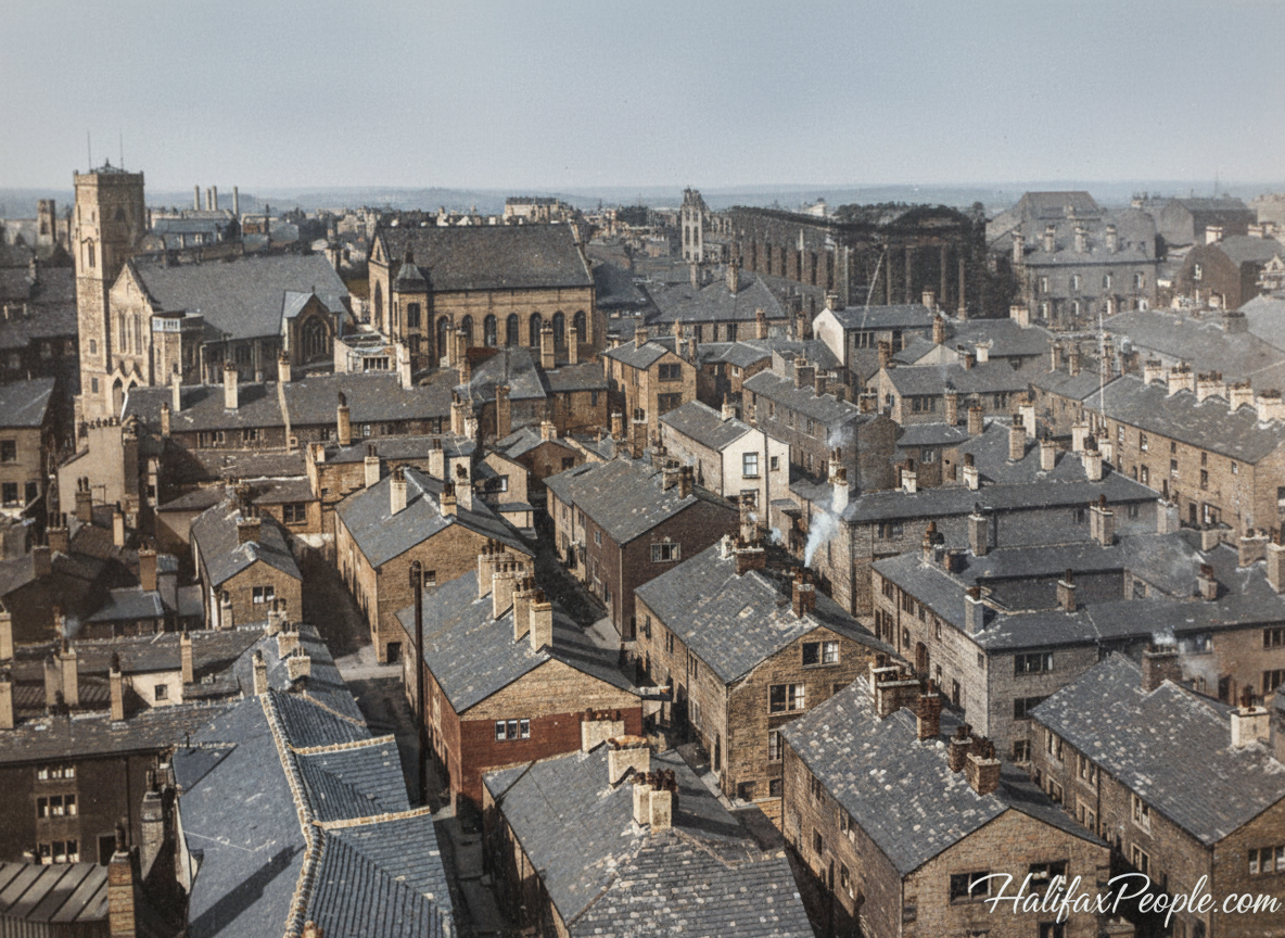


Richmond Street left and Stannary St right


Stannary Inn on the junction of 2 Green Lane and Stannary Lane. There was also a brewery here in cyyages known as Seedlings Mount. Opened in 1859 and closed in 1967 as part of the Burdock Way construction.


Steve Gee
Darley Street

Steve Gee

Lewis Street in 1966

South Darley Street

South Darley Street and Smiths Arms

The City residents

Green Hill Terrace in the Green Lane area between Stannary and Pellon Lane.


Green Hill Tavern was at 100 Pellon Lane. It opened in 1877 and closed in 1967.

The pub on the right is also Green Hill Tavern with 'The Weston' pub central.
 Weston Hotel or Western Hotel as it was known. Abel Street / 2 Lansdowne Place, Pellon Lane. |
 |

The empty building in the foreground is the former Commercial Road shop of the Halifax Industrial Society


J.Rhodes (pawnbrokers) on St.James's Road at the junction with Fleet Street (where the benefits office now stands).

Fleet Square off Fleet Street


A.Farrar upholsterers at 28 St.James's Road

on the left was the fish and chip shop run by M.Dolphin

Barbers shop, coal merchants Harries and Co, L.Arnott's ladies' and gents' tailors, I.Pollard's fish, fruit and poultry shop and a butchers offering 'choice horse flesh'.


Please add your own picture and articles for everyone to enjoy by either
Email:- info@halifaxpeople.com
or
Fill out the form at the bottom of each page
Explore More of Halifax:
🔹 An Historic Tour of Halifax — Walk through the town's past
🔹 George's Square — The heart of Halifax town centre
🔹 Halifax Breweries — The Cock O' The North and more
🔹 Halifax Pubs Past and Present — The pubs these workers drank in

Have A Great Story About This Topic?
Do you have a great story about this? Share it!
If you have enjoyed your visit to this website, please spread the word by clicking the 'like' and 'share' buttons below. Thank you