Historic Claremount Page 2
Historic Claremount Page 2


St Thomas Street looking south past the Claremount Tavern and on the right is St Thomas Church schoolroom

Dover Street 1967 (no's 12-2)

Dover Street 1967 (no's 11-1)

Earl Street W.C's and middens 1967

Brown Street

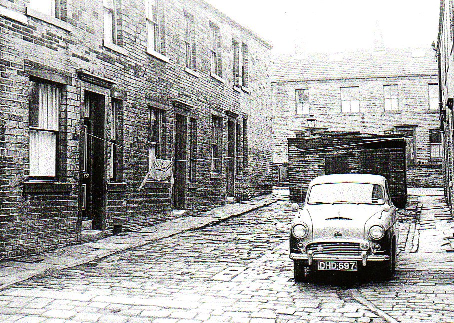
St Luke's Street with St Thomas's at the bottom

Gable end of St Luke's Street. W.C's middens etc. Horley Green Road in the distance

St Luke's Street 1967 (no's 18-2)

Sanderson Street 1967 (no's 4 & 2)

Sanderson Street 1967 (no's 13-1)

Walshaw Street, south side. Sheds, WC's, garages etc 1967

Walshaw Street 1967 (no's 1-3)

St Thomas Street looking North as far as George Swift premises 1967 (no's 20-24)

Sanderson Street 1967 (no's 29-15)

Sanderson Street pens, sheds and garages, south side, 1967

Dover Street 1967 (no's 28-14)

Cross Street looking north past Claremount Fisheries 1967

View south along Cross Street and showing gable ends of Parker Street, Neville Street, St Marks Street and Sanderson Street 1967

Parker Street towards Cross Street 1967


Neville Street middens and WC's 1967

North side of Hollin Street, Upper Horley Green looking east 1967

South side of Hollin Street looking West 1967

South side of Hollin Street looking West 1967

South side of Hollin Street looking West 1967

South side of Hollin Street looking West 1967

Back to the "Beacon" which was closed in 1968 and no's 4-14 St Thomas Street 1967.
-
Now we shall head right towards Horley Green

Beacon Terrace during demolition (no's 1-9)

Salubrity Street right side from Primrose Street 1967

Sarah Street from Primrose Street

Salubrity Street left side from Primrose Street

Salubrity Street right side from Primrose Street

Union Court left side from Cowper Street

Freedom Court from Cowper Street

Horley Green Road looking north-east 1967

Camden Street from Horley Green Road 1967

Corner of Horley Green Road and Belmont Street


Green Street from Horley Street

Sour Milk Hall, 14/16 Horley Green Road/Miles Street, closed in 1960 and was demolished in 1976


Belmont Street facing north from Horley Green Road

Miles Street from Horley Green Road. Claremount Post Office 1967


Horley Green Mills, Standeven & Co Ltd 1967

Primrose Street from Lily Street. Claremount Liberal Club 1967

Alma Road from Primrose Street

Dale Street from Primrose Street

Belgrave Street left side from Horley Green Road

Belgrave Street right side from Horley Green Road

Horley Green Road from corner of Gadd Street

Gadd Street from Horley Green Road

Claremount House 1967
Horley Green Villa


Henry Court west side from Havelock Street (no's 1-3)

Henry Court east side from Havelock street (no's 2-6)

Oates Court west side from Havelock Street 1967
Oates and Green


Gable ends of West Field Court, Ashfield Court, Henry Court and Oates Court. These were built on the north side of Havelock Street 1967

Horley Green Road looking south towards Camm Cottage

Camm Cottage, Horley Green Road

Horley Green Road looking south from Camm Cottage 1967

Horley Green Dam


View of Range Bank, Ellen Royd and Haley Hill from Claremount Road. 1930's
(Yorkshire Post)

See High Sunderland
Return to Historic Claremount
If you have enjoyed your visit to this website, please spread the word by clicking the 'like' and 'share' buttons below. Thank you
Are you wanting to find information on a specific Halifax subject? Search here
